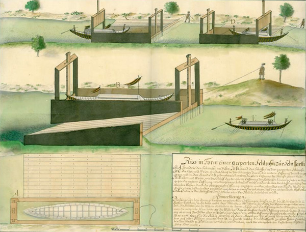
 Period picture of a lock that is identical with the historical lock in Rohatec
History of the research
Written reports indicate that a monoxylon is supposed to have been found in the hinterland of the village of Rohatec. This monoxylon is said to have been pulled out from the river in the first half of the 20th century. The written sources say nothing more about the “life story” of this type of dugout canoe.
The lock from the year 1722 is known from written sources not only as part of the existing watermill but also as part of the planned waterway Danube - Oder - Elbe. The lock in Rohatec, built by Oberstwachmeister Herbert von Linck from the stronghold in Uherské Hradiště, became the oldest waterwork of this type in the Czech Republic. From that time, the Morava and the Odra rivers were navigable for small vessels with tonnage of 10 tons.
It may be assumed that the lock was damaged by a flood and that it was at that time when a vessel took a shelter in the lock; the torso of this vessel could then be found there. At that time, vessels from Danube, called “šesterkas”, came to the Morava River, namely to Hodonín and Veselí nad Moravou; they brought salt and tobacco, and returned with lignite.

Research
At the time of the research, the visibility in the river was very bad, max. 30 cm. The current was gentle, so the cloudy water could be cleared very slowly. Water temperature was 24 °C.
The researched area is located in the hinterland of the village of Rohatec – Kolonie (called Rohatec – Mlejn in the past). And it was this mill that was associated with the construction of the lock related to the year 1722. The researched area was located between the road and the rail bridge, closed to the road one, specifically 137,8 metres up the river. This section of the Morava River,meaning upstream from the road bridge almost to the town of Veselí nad Moravou (better said to the village of Vnorovy), is not affected by river regulation, and for this reason, further archaeological situations can be expectedwithin this space. The riverbed shows a homogenous layer of medium-fine sand, whereby the layer thickness considerably exceeds one meter. Even though the water level dropped significantly at the time when the research was conducted, the river minimum depth was 2,5 meters and the maximum one up to 7 metres. The remnants of the waterwork from the first half of the 18th century lay at the depth of 4 metres.
See more in the pdf-document...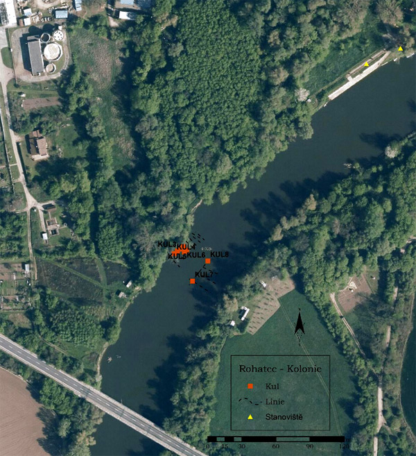 Waterwork localisation seen from the road bridge